Mapping spatial data
Abstract
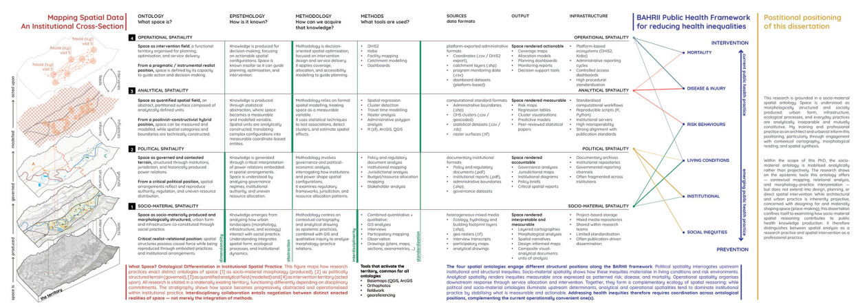
Spatial data have become increasingly central to public health research, yet the concept of space itself often remains implicit. While advances in geospatial technologies have expanded the availability and precision of spatial data, less attention has been paid to how researchers understand the spatial concepts that underlie their work. This project investigates how space is conceptualized, operationalized, and mobilized across diverse domains of public health research.
Using a qualitative exploratory design, we conducted semi-structured interviews with researchers working in epidemiology, public health, urban health, anthropology, geography, implementation science, and related fields. Participants were invited to reflect on the spatial dimensions of their research, the types of spatial data they use, and the assumptions embedded in their methods.
The analysis reveals substantial diversity in how space is understood and used. Participants described space not only as a measurable geographic location but also as lived environments, social relations, networks of mobility, material infrastructures, and administrative constructs. Across disciplines, tensions emerged between increasingly precise spatial measurements and the complexity of the social and environmental processes they are intended to represent. The findings suggest that spatial data are shaped by underlying theoretical assumptions, methodological choices, and practical constraints.
By making these conceptualizations explicit, the project contributes to ongoing discussions on the role of spatial thinking in public health and provides a foundation for more reflexive and theoretically informed uses of spatial data in health research.
Products